Spēg's 2007 Chase scorecard:
UPDATED: 4/30/2007: Added another lightning shot (or cropped) from April 23 showing a forked cloud-air bolt.
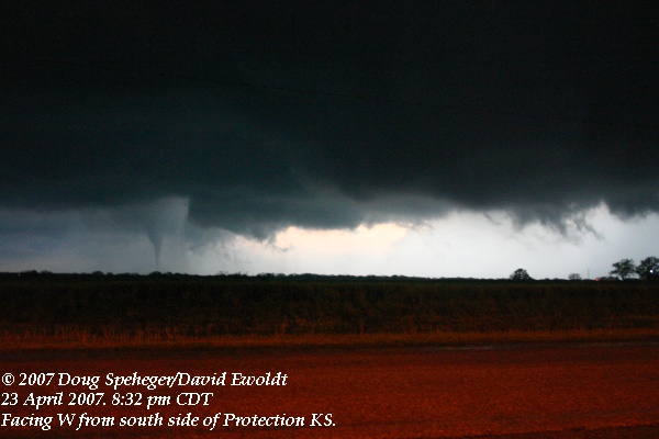
Monday, April 23 - Buffalo OK/ PROTECTION KS
595 miles, 15 hours. Supercell with 3 (?) tornadoes
|
The storm seemed to always be in transition with fast development and then disorganization. As the storm moved northeast through Harper County, we did see a brief tornado to our west. Unfortunately, we were driving and a ridge to the west cut off our view soon after we saw it develop (and thus, no picture.) When we got another view a couple of minutes later, it was already gone. There always seemed to be a lot happening and often more than one area of interest under the storm as it continued to move northeast. As the storm approached the state line, it became much more organized and developed very strong rotation and upward motion, with some scud tags developing just a few hundred feet above the ground, rising quickly, and rotating around a radius of a few hundred yards. It was some of the most impressive motion that I have seen, but never developed a condensation funnel or any typical visual cues of a tornado despite the strong very low-level rotation. After a few minutes, this rotation disorganized. With poor road options to stay with the storm, we left the storm for a while to drive north into Kansas, then east to near Protection KS and get ahead of the storm. As the storm approached, a tornado developed southwest of town and moved north or north-northeast. While this tornado was in the occluded part of the storm, another tornado developed to its east, closer to (but still west) of town. Although the second tornado looked like it was going to develop into an organized and large tornado, the visual contact with the ground was brief and it looked like it was constantly in a "incipient" tornado stage. We could confirm it in contact with the ground a couple of times. Meanwhile, the tornado in the initial area of the storm continued, even with the second area of interest (above left, or with radar) continuing to try to organize to its east. We have heard rumors that there may have been multiple tornadoes in the western area, but we could not tell for sure from our distance, although our initial guess was that we were watching a single, 15-minute (approximately) tornado. The second area also continued to develop visible funnels and perhaps brief contact with the ground as we lost sight of the western tornado in the rain and darkness. We followed the storm north of Protection, but did not have the best visibility with the growing darkness after sunset. After turning around and beginning the journey home, we saw that the storm was continuing to put on a lightning show (cropped image). So we stopped and photographed the lightning (cropped image) for a while. One more shot (or cropped) showing a forked cloud-air bolt. Dave's summary and some additional video captures are on his web site. |
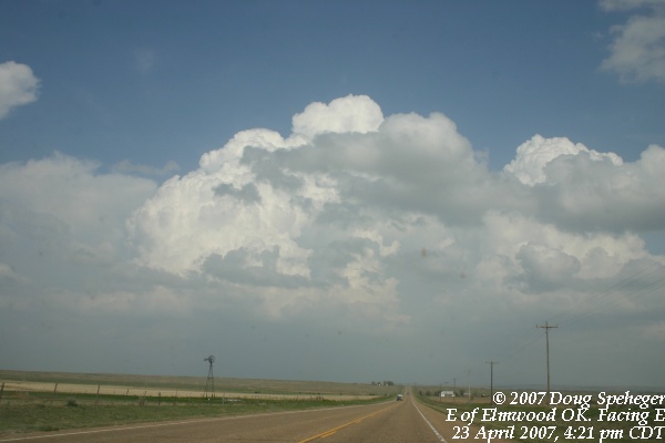
 We initially were targeting the eastern Oklahoma panhandle and drove out to Elmwood, OK. We were
pretty close to the initial nearby development that began to develop
We initially were targeting the eastern Oklahoma panhandle and drove out to Elmwood, OK. We were
pretty close to the initial nearby development that began to develop
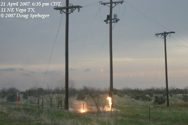
Saturday, April 21 - CHANNING/ Dumas TX
737 miles. 15 hours. Supercell with 2 large and long-lived tornadoes
|
The tornado became obscured by rain, but we saw it again NE of Channing near where it passed FM-722 to our east downing trees and power lines along a 0.4 mile wide damage path. As we moved east, another tornado developed to our northeast, a few miles east of the original tornado. It became quite large as well. While tornado #1 slowly dissipated (close view or wide view), tornado #2 became larger and obscured by rain as this poor contrast photo shows. Unfortunately, this tornado moved toward Cactus, TX. Dave's summary and some additional pictures and video captures are on his web site. |
 Although there was a lot of uncertainty in how things were going to develop, the forecast wind
shear was impressive so Dave Ewoldt and I went out to the Texas panhandle. We hung out on the
west side of Amarillo for a while watching showers try to develop to the northwest, west and
southwest while eating some "lucky breadsticks." A couple of storms developed to the southwest, so we went southwest into Deaf Smith
County. After some development, the storm began to produce some organized structure and a
couple of attempts to cycle and develop a wall cloud at
Although there was a lot of uncertainty in how things were going to develop, the forecast wind
shear was impressive so Dave Ewoldt and I went out to the Texas panhandle. We hung out on the
west side of Amarillo for a while watching showers try to develop to the northwest, west and
southwest while eating some "lucky breadsticks." A couple of storms developed to the southwest, so we went southwest into Deaf Smith
County. After some development, the storm began to produce some organized structure and a
couple of attempts to cycle and develop a wall cloud at
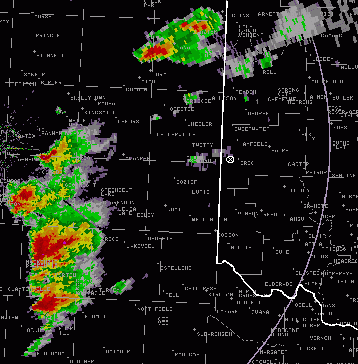
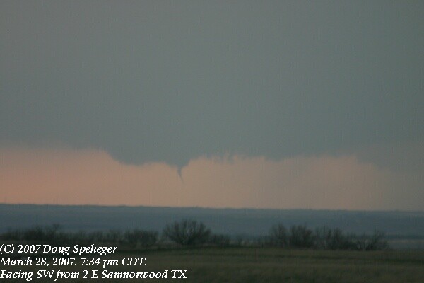
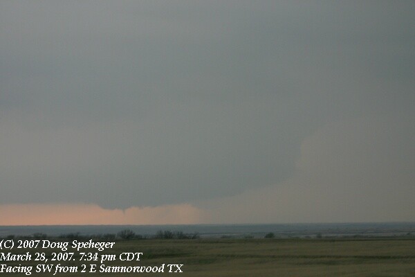
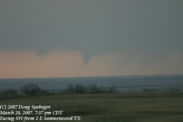
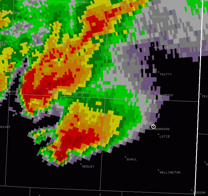
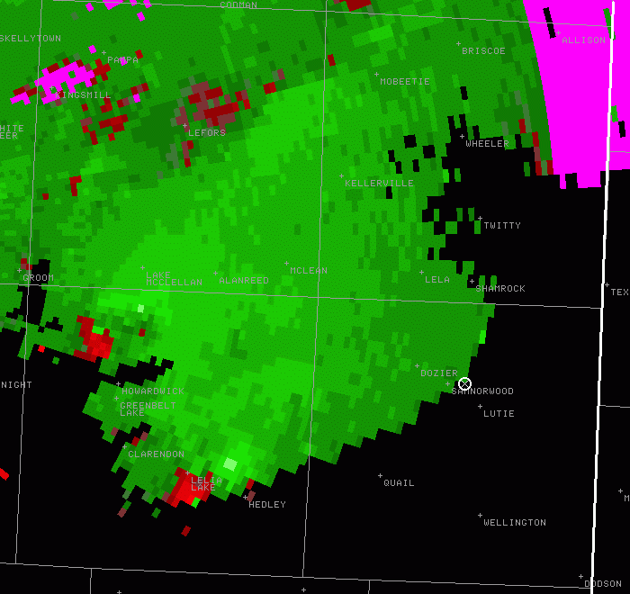
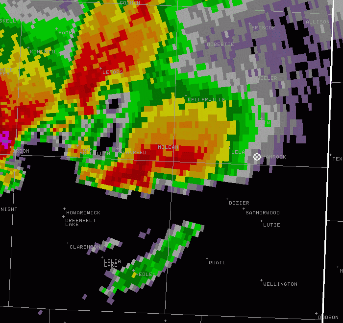
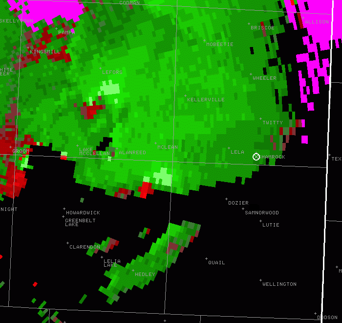
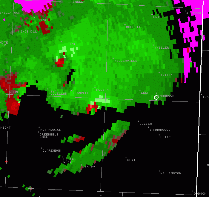
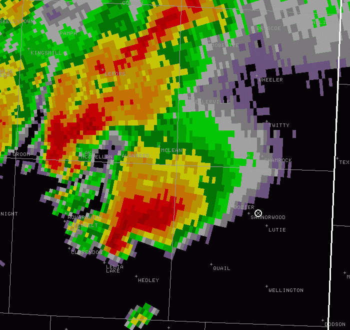
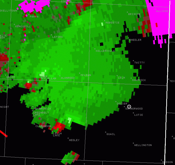
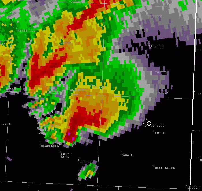
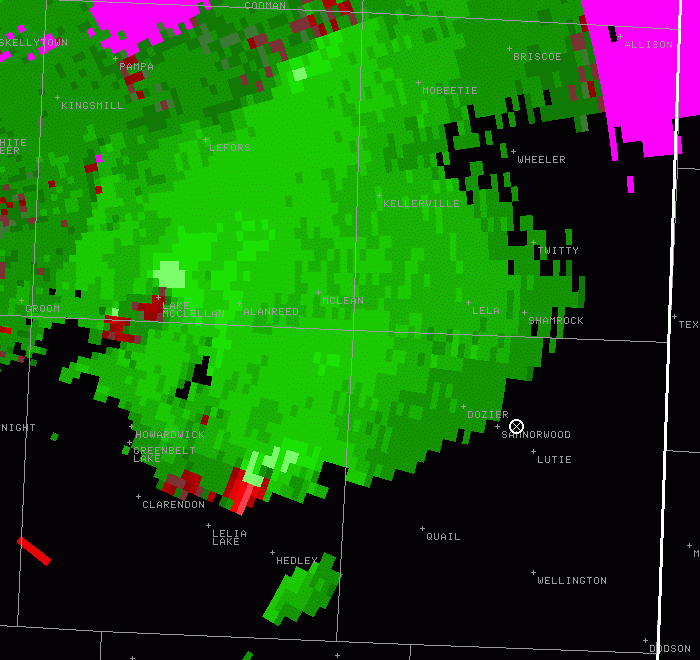
Wednesday, March 28 - SAMNORWOOD/ Hedley TX
463 miles. 8:20. supercell with 4-5 funnels (and a probable tornado or two)
|
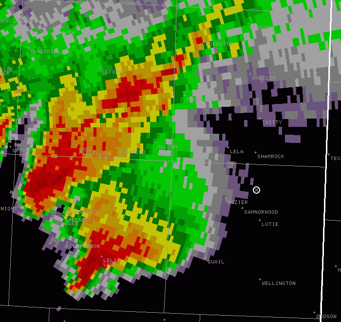
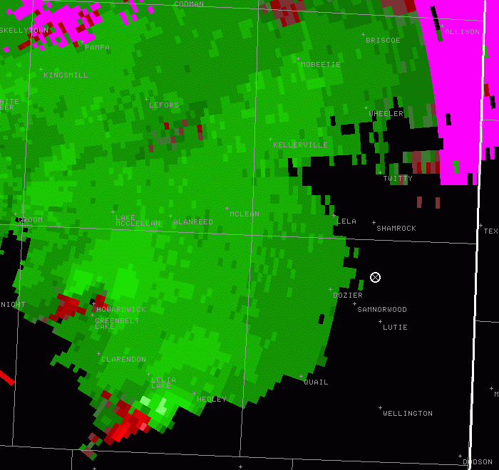
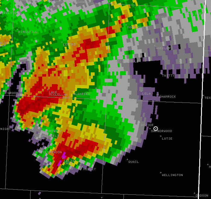
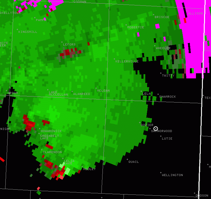
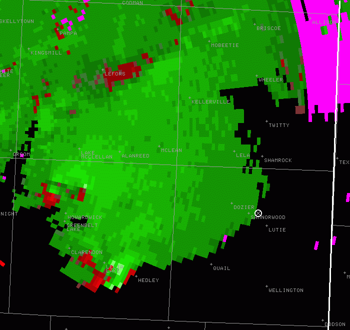
We eventually went to Shamrock TX and drove south to get a view of the south storm(s) before dark. We quickly were able to see peeks of the updraft base from the southern-most storm [radar: reflectivity, storm-relative velocity] that looked to include at least a funnel at 7:23 pm. We found a high vantage point near Samnorwood TX, and by the time we got the camera gear out at 7:27 pm, the initial funnel had dissipated. But we saw three more well-developed funnel clouds within the next 10 to 15 minutes. The first funnel after we stopped (funnel #2) was at 7:28 pm CDT [radar: reflectivity, storm-relative velocity]. I finally got decent pictures of funnel #3 at 7:34 pm close-up and wide view with storm structure. [radar: reflectivity, storm-relative velocity]. And then funnel #4 from 7:36 to 7:38 pm: close-up and wide view with storm structure (left) [radar: reflectivity, storm-relative velocity]. We could not confirm contact with the ground, but I think it is probably that at least one was a tornado, especially with this 4th funnel cloud (left). When looking at the large photo images on the computer, I thought I could confirm debris with developing funnel #3 (cropped picture), but I think it may be a structure - perhaps an elevator near Hedley TX to our southwest. The highly visible funnels (or tornadoes) dissipated, but a thought at times that I was getting a glimpse of something hidden in poor contrast near the rain core to the north of the initial funnels. And there were tornadoes reported between Hedley and McClean at these times. So I may have caught a brief glimpse of a more well-developed tornado as well. It had been suspicious enough that we stopped on the south side of Shamrock to see what we could see in the diminishing light [8:11 pm radar: reflectivity, storm-relative velocity; 8:15 pm radar: reflectivity, storm-relative velocity]. Overall, not the best of luck considering everything that was out there. But we salvaged some very nice storm structure and distant funnels (or tornadoes) after being stuck in a stormless area. Other radar pictures: 7:45 pm reflectivity, 7:45 pm storm-relative velocity 7:50 pm reflectivity, 7:50 pm storm-relative velocity |
 We got a late start since I had to sleep after a midnight shift. We were still in western Oklahoma when
the initial storms north of Memphis TX and NE of Lubbock TX developed and were initially targeting the storm near Memphis,
but it had dissipated by the time we got near the border. Unfortunately, we found ourselved in a large gap between storms.
There was some decent towering cumulus nearby and even radar echoes that we thought might develop [
We got a late start since I had to sleep after a midnight shift. We were still in western Oklahoma when
the initial storms north of Memphis TX and NE of Lubbock TX developed and were initially targeting the storm near Memphis,
but it had dissipated by the time we got near the border. Unfortunately, we found ourselved in a large gap between storms.
There was some decent towering cumulus nearby and even radar echoes that we thought might develop [
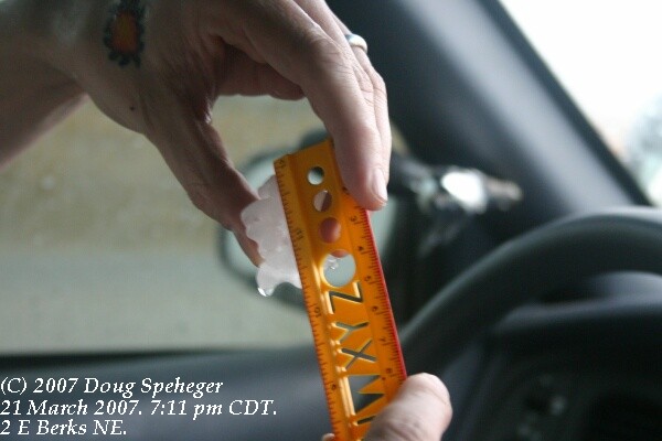
Wednesday, March 21 - Lincoln/ SPRAGUE NE
931 miles, 16:15. Two supercells
|
The low pressure developed a bit farther north, and storms formed along the cold front in Nebrsaka and we continued north into Nebraska for (surprisingly) my first Nebraska chase. We initially targeted the southern storm south of Seward to the northwest side of Lincoln. The picture on the right is the first chase photo with the digital camera at our first stop to look north of Milford. As we followed the storm to near the Lincoln airport, another storm developed to the southwest and we targeted that storm. Hail began to fall and we measured 1.5" hail E of Berks NE but saw what appeared to be golf balls nearby, and again measured 1.5" hail that we encountered on the ground SE of Berks. The storm had some decent scud development and rising motion for a few minutes in southern Lancaster County as we travelled east toward Sprague NE, but only weak circulation. The storm then appeared to disorganize somewhat as additional thunderstorms developed to the southwest. Overall a decent opening volley of the 2007 season. Dave's summary and a couple of additional photos are on his web site. |
 It was a day off, and I hitched a ride with Dave Ewoldt who was going to target north central
Kansas near Concordia KS near or northeast of a surface low. Storms would likely form on a cold
front in Kansas, and although not necessarily a fan of cold front storms, we were targeting the
area near the low where there appeared to be sufficient wind shear that could support supercells.
It was a day off, and I hitched a ride with Dave Ewoldt who was going to target north central
Kansas near Concordia KS near or northeast of a surface low. Storms would likely form on a cold
front in Kansas, and although not necessarily a fan of cold front storms, we were targeting the
area near the low where there appeared to be sufficient wind shear that could support supercells.